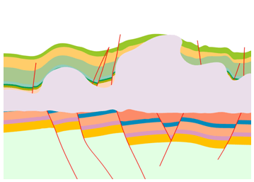
Most in the oil production business believe the era of easy oil discovery is over. Many of today’s oil & gas reservoirs are to be found in increasingly difficult locations with complex geologies. These locations include:
- Reservoirs with faults, which can break up communications between different layers within oil and gas reservoirs
- Reservoirs with complex fractures, i.e. breakages within the rock
- Sub-salt reservoirs, such as offshore Brazil and in the Gulf of Mexico
Emerson’s Tyson Bridger, a member of the Roxar brand team based in Norway noted that with salt, it’s often very difficult to develop clear pictures of the reservoir. It’s difficult to see the target and to map and understand reservoir geometries. It’s also difficult to answer questions such as, “Where is the structure holding the oil?”; “What does it look like?”; and, “How heterogeneous and fractured is the reservoir matrix?”
Tyson shared how reservoir modelling can help. In many cases, many reservoir modelling software packages oversimplify such complex geologies and make reservoir compromises. He pointed out that oversimplifying the obvious geological complexities within a reservoir is not going to deliver the vital information operators require for oil & gas well planning and production maximization.
 Last May, Emerson announced the Roxar RMS 2011 reservoir modelling solution, which is targeted specifically at tackling these complex geologies. It uses processing techniques such as reverse time migration (RTM) to produce higher quality seismic imaging. The 3D reservoir model shows the entire geological section from target to surface and handles it as a single entity.
The model captures fault linkages to highlight the details where the reservoirs are located and how they communicate with each other.
Shale gas formations provide their own set of challenges and geological complexities. These are vital for operators to understand, prior to drilling and embarking on expensive hydraulic fracturing drilling programs. Reservoir faults can divert hydraulic fracturing and lead to reduced pressures and the well abandonment.
For these shale gas formations, the reservoir modelling process starts with building a structural or framework model that defines the reservoir’s vertical and lateral extension. Then, the cells in the 3D grid are defined with the reservoir’s characteristics–properties such as rock types, porosities, permeabilities and hydrocarbon saturation. Conceptual models, trends or seismic attributes can all be used to guide the distribution of rock types, permeabilities or any other parameters the operator wishes to use in the 3D model.
Understanding shale gas fields through this 3D modelling process helps to predict the fracture density away from the wells, and the fractures that are most likely to contribute to the flow. It is also important to be able to model the dynamic properties of the fractures in a way that is consistent with observation.
Using tools such as RMS 2011 helps avoid oversimplification and better represents the field’s complexity, which in turn leads to more productive drilling and higher ongoing production rates.


